Mount Keilir
Mount Keilir is a perfectly cone-shaped volcanic peak on the Reykjanes Peninsula, rising 379 metres above the lava fields. The hike to the summit rewards with 360-degree views over the peninsula, the ocean, and on clear days, Reykjavik.
The Perfect Cone
Mount Keilir is the most recognisable peak on the Reykjanes Peninsula — a near-perfect volcanic cone rising from the flat lava fields like a green-grey pyramid. At 379 metres, it is not particularly high, but its isolation and symmetry make it look far more imposing than its elevation suggests. From Reykjavik, it is visible on clear days as a distinctive pointed silhouette on the southwestern horizon.
The mountain is a hyaloclastite formation — built from volcanic material that erupted beneath a glacier during the last ice age. The cone shape was preserved because the surrounding lava fields are much younger and flatter, making Keilir stand alone in the landscape.
The Approach
The hike begins from a parking area near the road between Keflavik and Grindavik. The first section crosses flat lava field terrain — old, moss-covered lava with a well-worn path winding between the rocks. This section is easy walking but exposed to wind, which on the Reykjanes Peninsula can be significant.
After about 3 kilometres, the trail reaches the base of Keilir's cone. Here the character of the hike changes completely. The ground steepens sharply, and the surface transitions from solid lava to loose volcanic scree and gravel.
The Summit Push
The final 200 metres of elevation gain are the crux of the hike. The slope angle increases to roughly 30-35 degrees, and the ground is loose — two steps up, one step sliding back. There is no single path; hikers pick their own line up the scree slope. It is physically demanding but not technically difficult. Take your time, place your feet carefully, and use hiking poles if you have them.
The summit itself is a narrow ridge with space for only a few people at a time. The views are spectacular — 360 degrees of Reykjanes lava fields, the Atlantic Ocean, the Fagradalsfjall eruption area, and on a clear day, the Reykjavik skyline and Snaefellsjokull glacier in the distance.
Recent Volcanic Activity
Keilir gained renewed attention during the Fagradalsfjall eruption of 2021, when seismic activity in the area raised concerns that Keilir itself might erupt. It did not, but the eruptions in nearby Geldingadalir and Litli-Hrutur (2021-2023) transformed the landscape around the mountain. From the summit, the fresh black lava flows from these eruptions are clearly visible, a stark contrast to the green moss of the older terrain.
Getting There
From Reykjavik, drive south on Route 41 toward Keflavik airport. The trailhead is near Asbru (the former NATO base), approximately 40 minutes from the city. Parking is in a gravel area near the trail start. The approach is well signed. There are no facilities — bring all water and supplies.
Frequently Asked Questions
- How long is the hike?
- The round trip from the parking area near Keflavik is approximately 9 kilometres with about 350 metres of elevation gain. Most hikers complete it in 3 to 4 hours. The approach across the lava field is relatively flat, but the final ascent to the cone summit is steep and loose.
- Is the summit climb dangerous?
- The final push up the cone is steep with loose scree and gravel. It requires good fitness and sturdy footwear. There is no fixed path on the steepest section — you scramble up loose volcanic material. It is not technical climbing, but it demands caution. Not recommended in wet or windy conditions.
- Can I see the recent eruption sites?
- Yes, from the summit of Keilir you can see the Fagradalsfjall and Litli-Hrutur eruption sites from 2021-2023. The fresh black lava flows are clearly visible against the older, moss-covered landscape. However, do not attempt to visit active eruption areas without checking current safety advisories.
- When is the best time to hike?
- June through September offers the best conditions — longer days, less wind, and no snow on the trail. Early morning starts avoid the afternoon wind that often picks up on the peninsula. Avoid hiking in poor visibility, as the approach across the lava field can be disorienting.
- Do I need special equipment?
- Sturdy hiking boots are essential — the terrain is rough lava rock and loose scree. Bring water (at least 1.5 litres), snacks, a windproof layer, and sunscreen. Hiking poles are helpful for the steep summit section. There are no facilities at the trailhead.
Book Unforgettable Iceland Experiences — Reykjavik
From glacier hikes to northern lights tours — browse hundreds of activities and book with free cancellation.
Browse ActivitiesMore Attractions in Reykjavik
See all →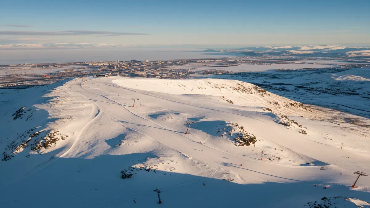 Reykjavik3-6 hours
Blafjoll Ski Resort
Iceland's largest ski resort, just 30 minutes south of Reykjavik in the Blue Mountains. Blafjoll offers 15 km of slopes, 14 lifts, night skiing under floodlights, and the chance to ski beneath the northern lights.
 Reykjavik15-30 minutes
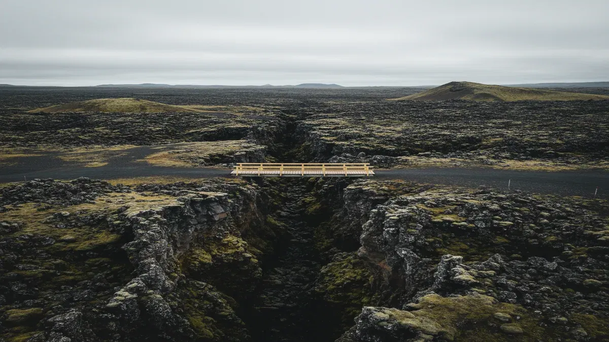
Bridge Between Continents
A 15-meter footbridge spanning a rift between the North American and Eurasian tectonic plates on the Reykjanes Peninsula, offering a symbolic walk between two continents in the middle of a vast lava field.
 Reykjavik45-60 minutes
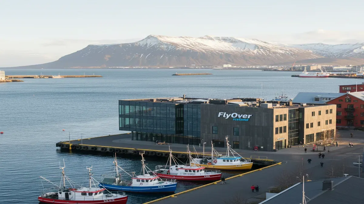
FlyOver Iceland
A state-of-the-art flying theatre in Reykjavik's Grandi harbour district where visitors are suspended before a 20-metre spherical screen for an immersive aerial journey across Iceland's landscapes, complete with wind, mist, and scent effects.