Krýsuvík
Krýsuvík is a geothermal area on the Reykjanes Peninsula with steaming hot springs, colourful mineral deposits, and Lake Kleifarvatn. The broader area includes the Seltún geothermal field, dramatic coastal cliffs, and a landscape shaped by the Mid-Atlantic Ridge.
A Landscape on the Fault Line
Krýsuvík sits directly on the Mid-Atlantic Ridge — the tectonic boundary where the North American and Eurasian plates pull apart. The earth here is visibly alive. Steam rises from cracks in the ground, mud pots bubble and spit, and the soil is stained in vivid yellows, reds, and whites by sulphur and mineral deposits. The landscape shifts and changes with each earthquake and each season.
The broader Krýsuvík area on the Reykjanes Peninsula encompasses several distinct sites spread across a volcanic terrain that ranges from geothermal fields to dark tectonic lakes to sea cliffs teeming with birdlife. It is one of the most geologically dynamic places in Iceland, all within 40 minutes of Reykjavik.
Lake Kleifarvatn
The drive to Krýsuvík from Reykjavik passes along the shore of Kleifarvatn — one of Iceland's deepest and most mysterious lakes. The dark water fills a tectonic fissure, with no visible river feeding it and no stream draining it. Water enters and leaves through underground channels in the porous lava.
After a powerful earthquake in June 2000, the lake level dropped dramatically as new fissures opened in the lakebed. Over the following years, it slowly refilled. Today, it sits in its barren lava landscape looking like something from another planet — dark, still, and deep. On a grey day, the atmosphere is genuinely eerie.
The Geothermal Fields
The Seltún geothermal area is the most visited part of Krýsuvík. Boardwalks lead through a colourful landscape of steaming fumaroles, boiling mud pots, and mineral-crusted ground. The colours are extraordinary — bright yellow sulphur, deep red iron oxide, white silica, and grey mud, all mixed together in patterns that shift with the geothermal activity.
The heat comes from magma relatively close to the surface, heating groundwater that emerges as steam and boiling pools. The smell of hydrogen sulphide (rotten eggs) is strong and inescapable. Stay on the boardwalks — the ground between the marked paths can be thin crust over boiling water.
Krýsuvíkurberg Sea Cliffs
To the south, the Reykjanes Peninsula drops into the Atlantic at Krýsuvíkurberg — a dramatic stretch of sea cliffs rising 45 metres from the ocean. These cliffs host one of Iceland's largest seabird colonies, with thousands of guillemots, razorbills, kittiwakes, and fulmars nesting on the ledges during summer. The access road is rough, but the reward is a wild, windswept viewpoint with birds wheeling below you and the Atlantic stretching to the horizon.
Getting There
From Reykjavik, take Route 42 south across the Reykjanes Peninsula. The drive passes Lake Kleifarvatn and reaches the Seltún geothermal area after about 40 minutes. Continue south for the Krýsuvíkurberg cliffs. The main road is paved, with gravel sections for the cliffs. No entry fees for any of the sites. Combine the whole area into a half-day loop drive from Reykjavik.
Frequently Asked Questions
- What is there to see at Krýsuvík?
- The Krýsuvík area encompasses several sites: the Seltún geothermal field with its bubbling mud pots and fumaroles, Lake Kleifarvatn (a deep tectonic lake), the Krýsuvíkurberg sea cliffs (one of Iceland's largest seabird colonies), and the abandoned Krýsuvík farm. Together they offer a half day of diverse landscapes.
- Is it safe to walk in the geothermal area?
- At the Seltún geothermal field, stay on the marked boardwalks. The ground around the hot springs is fragile and can be dangerously hot. Boiling water lies just below the surface in some areas. The boardwalks are well maintained and safe.
- What is Lake Kleifarvatn?
- Kleifarvatn is a deep, dark lake formed in a tectonic fissure on the Reykjanes Peninsula. It has no visible inlet or outlet — water seeps in through underground channels. After a major earthquake in 2000, the lake partially drained through new cracks in the lakebed, then slowly refilled. It is an eerie, beautiful place.
- Can I visit the sea cliffs?
- Yes, Krýsuvíkurberg is a 4-kilometre stretch of sea cliffs on the south coast of the peninsula, home to thousands of nesting seabirds including guillemots, razorbills, and fulmars. Access is via a rough track — a sturdy vehicle is recommended. The cliffs are unfenced.
- How does this differ from the Seltún geothermal area page?
- The Seltún geothermal field is one part of the broader Krýsuvík area. This page covers the wider landscape including the lake, sea cliffs, and surrounding terrain. Both are worth visiting and can be combined in a single trip.
Book Unforgettable Iceland Experiences — Reykjavik
From glacier hikes to northern lights tours — browse hundreds of activities and book with free cancellation.
Browse ActivitiesMore Attractions in Reykjavik
See all →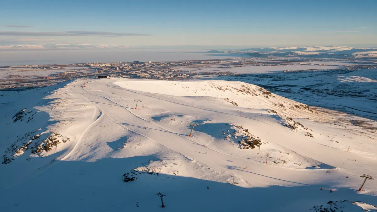 Reykjavik3-6 hours
Blafjoll Ski Resort
Iceland's largest ski resort, just 30 minutes south of Reykjavik in the Blue Mountains. Blafjoll offers 15 km of slopes, 14 lifts, night skiing under floodlights, and the chance to ski beneath the northern lights.
 Reykjavik15-30 minutes
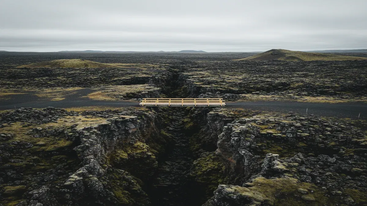
Bridge Between Continents
A 15-meter footbridge spanning a rift between the North American and Eurasian tectonic plates on the Reykjanes Peninsula, offering a symbolic walk between two continents in the middle of a vast lava field.
 Reykjavik45-60 minutes
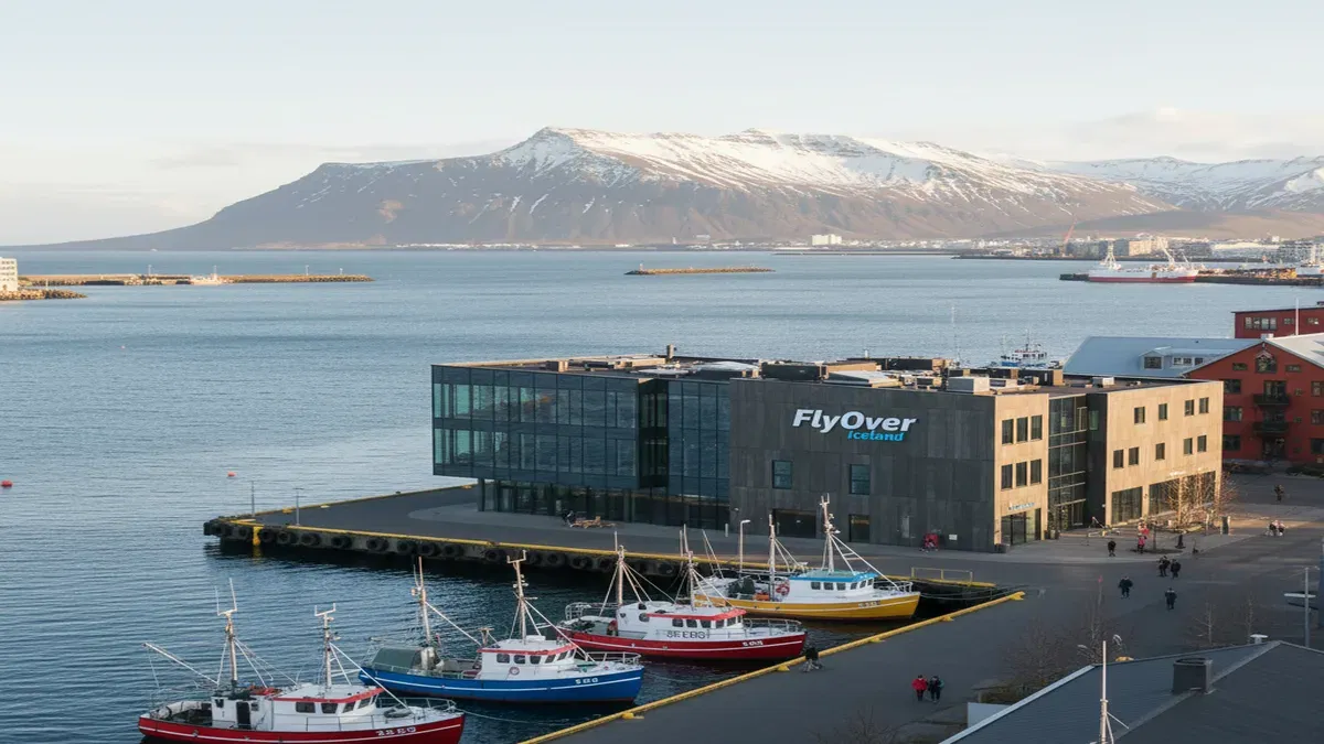
FlyOver Iceland
A state-of-the-art flying theatre in Reykjavik's Grandi harbour district where visitors are suspended before a 20-metre spherical screen for an immersive aerial journey across Iceland's landscapes, complete with wind, mist, and scent effects.